The
characterisation of the licence area
Most important
seismic investigations in the licence area were conducted during
three field seasons. 88 km of regional prospecting lines were shot in
1987 were shot based on the order of Joint Organisation PETROBALTIC. 354 km of lines were shot in 1989 based on the order of the USSR
Ministry of Oil Industry (the grid was 2x2 km). As a result of those
operations, the E23 and E25 structures were identified. 289 km of
lines were shot in 1991 based on the order of the Department of Geology,
Geodesy and Cartography of the Republic of Latvia. The purpose of those
operations was to investigate the Е23 and Е25 structures in
more detail using a denser line grid – 1x1 km. There was no drilling
in the area under discussion.
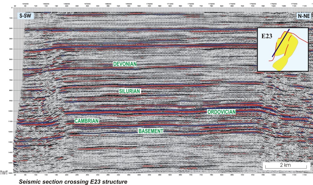
Four
regional reflectors were singled out on seismic sections, associated
with the top Lower Ludlow, top Ordovician, top Cambrian and top
crystalline basement. The Cambrian sandstone is prospective for
hydrocarbons in the area; the Cambrian oil deposits are successfully
developed in the adjacent areas: Lithuania, Kaliningrad District (Russia)
and Poland. That is why reflectors in the top Cambrian and top
Ordovician are target mapping horizons, which occur parallel to one
another.
According to the results of the latest reprocessing and interpretation
carried out in 1999 (raw data vintage 1987, 1989 and 1991), the
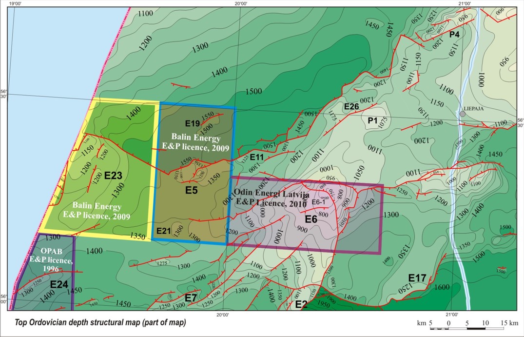
Е23 high is represented on the top Ordovician and top Cambrian
structural maps by a brachyanticlinal fold. In the north and west, the
structure bounds faulted zones with the amplitude exceeding 50 m. The
eastern flank of the high has small meridional faults, with two adjacent
brachyanticlinal folds. The total area of the high within the closing
isohypse 1300 m (on the top Ordovician structural map) comprises
approximately 240 km2; the amplitude is -180 m.
The
top Cambrian structural map does not cover the whole area of the E23
structure due to the limited area where the reflector has been
identified. Within the mapped area, the area of the high in the top
Cambrian within the contour of the 1360 m isohypse comprises 172 km2.
The depth of the Cambrian reservoir at the dome of the structure is 1200
m, the amplitude - 160 m. Based on the interpolation from the nearby
wells (E7-1 and P6-1), the parameters of the reservoir at the E23
structure could vary within the following limits (max/min): reservoir
thickness – 90/70 m, net/gross - 0.65/0.55, porosity – 15/13%.
Oil
in place at the E23 structure is estimated from 33 million m3
(minimum) to 670 million m3 (maximum).
According to the results of the reprocessing and
interpretation carried out in 1992 (raw data vintage 1984, 1987, 1989
and 1991), the E25 structure was located to the south from the E23
structure, in the southwesternmost part of the licence area. During the
comparison of structural patterns for all the reflectors (pre-Cambrian,
Cambrian, Ordovician and Silurian), a discrepancy of the dome locations
for separate reflectors was observed. The total area within the closing
isohypse -1375 m (the top Cambrian) is approximately 27 km2.
The maximum amplitude of the high is 25-30 m. According
to the results of the latest reprocessing and interpretation carried out
in 1999 (raw data vintage 1987, 1989 and 1991), existence of the E25 structure was not confirmed.
For relevant information about
the structural setting of the Baltic Basin, as well as locations and
characterisation of hydrocarbon accumulations, stratigraphy, reservoirs,
source rocks and hydrocarbon characteristics, see
the section Petroleum Geology.