 | |
 |
Regional
seismic data package
The
State Geological Survey of Latvia (since 2005, the Latvian Environment,
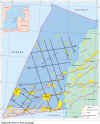
Geology and Meteorology Agency) has prepared a Regional seismic data
package aimed at the international oil industry. This seismic data
package includes a total of 1,145 km of seismic selected from 11 surveys,
acquired from 1976 to 1989. Archive stacks from different surveys were
reprocessed (Poststack reprocessing, 1998) using ProMax software, and
are now presented as composite regional lines showing main structural
elements in the Latvian part of the Baltic basin and tying the offshore
wells to a number of undrilled prospects.
LIST
OF REGIONAL SEISMIC LINES
|
Composite Line
|
Acquisition Line
|
Shot point range |
Composite linelength, km |
|
110
|
89110
|
33.0
|
47.0
|
96.7
|
|
|
83110
|
47.1
|
129.8
|
|
116
|
84116
|
14.6
|
93.4
|
92.3
|
|
|
87116
|
93.9
|
107.4
|
|
255
|
84255
|
86.0
|
129.7
|
96.7
|
|
|
82255
|
30.0
|
83.0
|
|
421
|
87421
|
12.9
|
25.4
|
57.5
|
|
|
78421
|
25.5
|
50.0
|
|
|
87421
|
50.0
|
70.5
|
|
511
|
78511
|
35.0
|
86.5
|
129.5
|
|
|
81511
|
87.5
|
113.0
|
|
|
84511
|
114.0
|
140.0
|
|
|
89511
|
140.0
|
166.5
|
|
044
|
76044
|
47.9
|
86.0
|
138.4
|
|
|
81044
|
86.0
|
107.6
|
|
|
82044
|
108.0
|
137.0
|
|
|
83044
|
137.1
|
168.5
|
|
|
88044
|
168.5
|
186.8
|
|
041
|
88658
|
75.5
|
87.8
|
113.8
|
|
|
81041
|
88.1
|
113.1
|
|
|
82041
|
113.0
|
141.0
|
|
|
83041
|
141.6
|
190.3
|
|
589
|
82589
|
100.0
|
140.0
|
89.6
|
|
|
83589
|
140.6
|
190.2
|
|
617
|
83617
|
140.5
|
191.0
|
50.5
|
|
622
|
83622
|
153.5
|
190.5
|
37.0
|
|
407
|
87407
|
124.5
|
137.1
|
33.1
|
|
|
78407
|
104.0
|
124.5
|
|
823
|
87823
|
102.5
|
137.0
|
34.5
|
|
401
|
89401
|
134.5
|
143.0
|
54.5
|
|
|
87401
|
127.0
|
133.5
|
|
|
78401
|
87.5
|
127.1
|
|
793
|
89793
|
145.5
|
176.5
|
31.0
|
|
522
|
78522
|
121.0
|
169.0
|
58.0
|
|
|
87522
|
169.1
|
179.1
|
|
544
|
79544
|
137.0
|
161.5
|
32.5
|
|
|
86544
|
166.0
|
174.0
|
|
16 lines
|
|
|
|
1,145.5 km
|
AVAILABLE
PRODUCTS:
 |
Print
sections |
 |
Original
Stacks
on tape in SEGY format (for part of lines only) |
 |
Migration
on tapes in SEGY format |
 |
Navigation
data in ASCII format |
 |
Demultiplexed
field records in the SEGY format are also available |
Note:
Only whole composite line can be purchased
|
GENERAL PROCESSING SEQUENCE OF REGIONAL SEISMIC LINES
|
Acquisition
parameters
|
Prestack
processing *
(1976-1989)
|
Poststack
reprocessing
(ProMax,
1998)
|
|
Source:
|
Air gun array
|
|
|
|
SP interval:
|
50; 25; 12.5 m
|
Spiking Deconvolution
|
Trace Equalisation
|
|
Cable length:
|
1150; 1175m
|
Vrms Analysis via Vertical Velosity
Spectra
|
F-D Time Migration
|
|
No. of channels:
|
24; 48
|
Normal Moveout Correction (NMO)
|
Coherency Filtering
|
|
Record length:
|
3s
|
F-K Filter
|
Adaptive Deconvolution
|
|
Sample rate:
|
4; 2ms
|
CDP Stack (12-24-48 fold)
|
Band-Pass Filtering (8-14-45-90)
|
|
Navigation:
|
SYLEDIS
|
Predictive Deconvolution
|
|
*
Prestack processing was carried out using CYBER (1976-1979) and SDS-3
(1980-1989) software.
©
LATVIJAS VIDES, ĢEOLOĢIJAS UN METEOROLOĢIJAS CENTRS
©
LATVIAN ENVIRONMENT, GEOLOGY AND METEOROLOGY CENTRE
|


