

 | |
 |
Onshore
seismic data
During
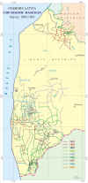
1958–1971, onshore 1-fold reflection seismic surveys were carried out,
12,000 line km altogether, and are available only as maps based on
original seismic data.
An
additional, about 1,700 line km of CDP seismic were acquired in the
western onshore Latvia from 1985 to 1993 and are available in the SEG-Y
format. Seismic
data available to the oil industry for purchase and inspection are
listed below.
Note:
some of the seismic lines shown on the map could be unavailable, because they
have been lost or damaged.
List
of offshore surveys
|
Acquisition
year
|
Number
of lines
|
Total
length, km
|
Method
|
Location
|
|
1957-1971
|
|
about
12
000
|
1-fold
reflection
|
Western
and Central Latvia
|
|
1985
|
1
|
11
|
CDP
|
South
Western Latvia onshore
|
|
1986
|
21
|
221
|
CDP
|
South
Western Latvia onshore. Bernati, Perkone, Pape
|
|
1987
|
27
|
203
|
CDP
|
South
Western Latvia onshore. Bernati, Perkone, Pape
|
|
1988
|
28
|
319
|
CDP
|
South
Western Latvia onshore. Bernati,
Nica, Perkone, Pape, Pecukapas, Barta, Lidumi, Rucava, Bumbuli,
Sprudi, Kirbas, Garkaji, Vismini
|
|
1989
|
30
|
263
|
CDP
|
South
Western Latvia onshore. Bernati,
Nica, Perkone, Pape, Pecukapas, Barta, Lidumi, Rucava, Bumbuli,
Sprudi, Kirbas, Garkaji, Vismini
|
|
1990
|
7
|
47
|
CDP
|
South
Western Latvia onshore. Nica,
Pecukapas, Kuldiga
|
|
1991
|
55
|
320
|
CDP
|
South
Western Latvia onshore. Kuldiga, Vismini, Barta, Sprudi,
Garkaji, Dunika, Bumbuli
|
|
1992
|
18
|
175
|
CDP
|
|
|
1993
|
18
|
114
|
CDP
|
South
Western Latvia onshore. Kuldiga, Liepaja
|
|
©
LATVIJAS VIDES, ĢEOLOĢIJAS UN METEOROLOĢIJAS CENTRS
©
LATVIAN ENVIRONMENT, GEOLOGY AND METEOROLOGY CENTRE
|


