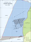
 | |
 |
OFFSHORE LATVIA
|
SURVEY
YEAR:
|
|
|
LENGTH:
|
1337
km (48 lines)
|
|
LOCALITY
|
Eastern
Central shelf
|
|
OPERATOR:
|
PETROBALTIC
|
|
CONTRACTOR:
|
MORINZHGEOLOGIYA
|
|
DATE:
|
V-IX 1982
|
|
|
|
ACQUISITION
PARAMETERS:
|
|
SOURCE:
|
High pressure
air gun array
|
|
SP
INTERVAL:
|
25m
|
|
GROUP
INTERVAL:
|
50 m
|
|
CABLE:
|
24 channels,
1150 m
|
|
OFFSET:
|
350 m
|
|
RECORDING
INSTRUMENT:
|
SSC 3, SSC 4 (Soviet
made)
|
|
SAMPLE
RATE:
|
2 ms
|
|
RECORD
LENGTH:
|
3 sec
|
|
FOLD:
|
2400 %
|
|
NAVIGATION:
|
SYLEDIS
|
Available data:
 |
Digital field records,
SEGY format |
 |
Original (old) stacks
on tape for some lines, SEGY format |
 |
Reprocessed data, SEGY
format (refer to Reprocessed data, E17 and P4 areas) |
 |
PostStack reprocessed
data, SEGY format (refer to Regional Seismic Data Package) |
 |
Navigation data, ASCII
format |
Note:
The
seismic data from the disputed area (marked in grey on the map) between
Latvia and Lithuania are available only for inspection in the offices of
the State Geological Survey of Latvia (SGSL). |
©
LATVIJAS VIDES, ĢEOLOĢIJAS UN METEOROLOĢIJAS CENTRS
©
LATVIAN ENVIRONMENT, GEOLOGY AND METEOROLOGY CENTRE
|


